When you upload an image map of your yard, N4 saves the source of the image in the database and retiles it on each application server.
You can use a CAD drawing or an aerial image of your yard to create your image map. In addition, you can use a high resolution image of your yard from the Google Earth plugin or from Google's satellite views. If you use a satellite view from Google, you must save it at a resolution that would equate with the recommended 1 pixel per 30 cm (approximately 1 foot).
Table: Yard image map considerations
|
Example Yard |
Metric |
American |
||
|---|---|---|---|---|
|
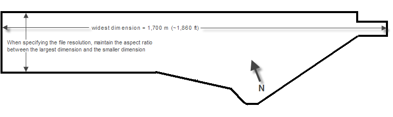
Widest dimension |
1,700 meters |
1,860 yards |
||
|
Recommended Resolution |
1 pixel per 30 centimeters
|
Example: 1,700 m x 100 cm/m = 170,000 cm/30 cm/pixel = 5,666 pixels Therefore, save the image so that the size attribute for width, as measured in pixels, is 5,666. |
1 pixel per foot |
Example: 1,860 yards x 3 ft/yd = 5,580 ft x 1 ft/pixel = 5,580 pixels Therefore, save the image so that the size attribute for width, as measured in pixels, is 5,580. |
|
Minimum Resolution (not ideal) |
1 pixel per meter |
Example: 1,700 m x 1 m/pixel = 1,700 pixels Therefore, save the image so that the size attribute for width, as measured in pixels, is 1,700. |
1 pixel per 3.28 feet |
Example: 1,860 yards x 3 ft/yd = 5,580 ft ¸ 3.28 ft/pixel = 1,701 pixels Therefore, save the image so that the size attribute for width, as measured in pixels, is 1,701. |
|
Image File Format |
.jpg, .bmp, .png Try to maximize the visible detail in the image while maintaining a file size in bytes that is below 18 MB. The higher the resolution, the more you can zoom in on the image. Even if the image is blurred when zoomed deeply in, the spatial relationships applied by the Yard Editor are accurate. A high resolution .jpg file has a smaller file size than a .png or .bmp at the same resolution. The .jpg will be blurrier when you zoom in, but you will still be able to see the outline and enough detail to place existing blocks from the upgraded yard model or imported yard file while maintaining an acceptable file size. (See below.) |
|||
|
Image File Size |
Maximum 18 MB The image width or height cannot exceed 16384 pixels, which is the equivalent of a yard length of approximately 4.9 km (3 miles). |
|||
|
Image Processing Applications |
Paint (Microsoft) - A standard accessory on Windows machines. Specify pixel resolution using the Attributes menu. SnagIt (Techsmith) - A low-cost image capture and editor application. Specify pixel resolution using the Resize Image task. |
|||
|
Capturing a Satellite Image |
If you do not have access to a CAD file of your yard, or to a commissioned aerial photograph, you can use Google Earth or a Google satellite image. Zoom in as much as possible while still keeping the perimeter of the yard in the capture. |
|||
|
Orienting the Image |
Satellite images in Google Maps are oriented with North directly up on the screen. However, the viewing area in the Yard Editor is fixed as a horizontal rectangle. Rotate the image before you save it so that it is in the same orientation as it appeared in XPS before the upgrade. This makes it easier to place blocks. |
|||
|
Specifying Pixel Resolution (Resizing an Image) |
When specifying the file resolution (you can do this in any image program, such as Paint or Snagit, by scaling or resizing the image), maintain the aspect ratio between the largest dimension and the smaller dimension. Otherwise, the image stretches only in the smaller dimension, and your image map will not be useful for placing blocks. For example, if your original image is 779 x 232 pixels (a width to height ratio of 3.35776 to 1), and you calculate that to meet the recommended resolution for the larger dimension, you must save the width at 5,580 pixels, the height in pixels should be 1,661 (5,580 ¸ 3.35776). |
|||
|
Finding Latitude and Longitude Values |
You can find the latitude and longitude of two points in your yard using free web-based utilities that allow you to enter an address, and then let you drag and drop the marker to pinpoint different points. At the time of this publication, one example of such a tool could be found at http://itouchmap.com/latlong.html. Google Maps Labs also has a feature you can turn on to give latitude and longitude upon right-clicking a point on a Google map. South latitude and West longitude coordinates must take on a negative value when you enter them in the Reference Point form (on page 1).
When converting reference points from degrees, it is better to retain more precision after the decimal point to improve the accuracy of further conversions that occur when you place each yard element on the map. |
|||